Berliner Höhenweg 2012

Berliner Höhenweg Map
So this year we thought we’d return to Austria and have another attempt at the “Berliner Höhenweg” also called the “Zillertaler Runde” or even the “Zillertal Rucksack Route” (but not by the locals). We’d attempted this way back in September 2007 but were unexpectedly snowed off. This time we went in the last week of June and we still encountered a considerable amount of snow leading to longer days than the local signage might suggest.
Day 0: To Mayrhofen
We flew to Munich and took the train to Mayrhofen (to spend our first night in a nice hotel).
Accommodation: Hotel Robert
Day 1: Edel Hütte (2238m)
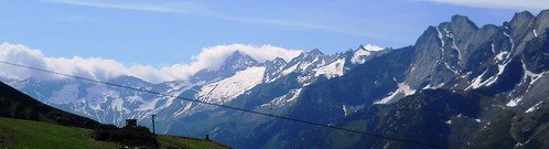
From Mayrhofen we took the Ahornbahn cable car to the Ahorn Plateau (1960m). We walked up to the Edel Hut for a quick lunch and then nipped up the Ahorn Spitz (2978m) for a little acclimatization and the spectacular view shown below.
Stats: Ascent: 1015m, Descent: 735m
Accommodation: Edel Hütte

View from the Ahorn Spitz (2978 m)
Day 2: Kasseler Hütte (2177m)
We awoke to heavy rain and a stern warning from the Hut Guardians not to attempt the Höhenweg route to the Kasseler Hut as it would be unsafe. We agreed as we had done this bit of the route before, and it is quite steep and exposed in places over slippery rock and old snow. Instead we took the cable car back down to Mayrhofen and got the bus up the Stilluptal valley to the Grüne-Wand Hut. From there we walked up to the Kasseler without difficulty.
Stats: Ascent: 750m, Descent: 45m
Accommodation: Kasseler Hütte

Difficult Snow Patches
Day 3: Greizer Hütte (2226m)
We set off in beautiful weather to meet a number of long gullies full of old snow which had frozen rock hard overnight. This gave us a tough morning of cutting steps with our ice axes and fairly slow progress until the sun started to soften the snow. By lunch time we were well under way and over the easy “fixed chains” of the Elsenklamm and then the high Lapen Scharte col (2707m). We descended to the Greizer Hut through a few more patches of soft steep snow. Overall a much longer harder day than anticipated.
Stats: Ascent: 815m, Descent: 720m, Time: 7.5hrs
Accommodation: Greizer Hütte
Day 4: Berliner Hütte (2040m)

Over Mörchen Scharte
The day to the Berliner Hut started with an descent of 400m into the head of the valley before turning up towards the Mörchen Scharte (2872m). On the ascent, we were immediately faced with a 15m ladder, closely followed by a zig-zagging route protected by fixed ropes. The ground soon became less steep for the majority of the ascent, although the final couple of hundred metres were a tricky choice between steep unstable screey mud, or steep soft snow full of holes. The steep remains of an old snow cornice at top of the col were very exciting, and the snow appeared to go on for miles on the far side. However we made good progress as the ground became less steep but again it was a longer day than expected.
Stats: Ascent: 1085m, Descent: 1230m, Time: 8hrs
Accommodation: Berliner Hütte

View from the Schönbichler Horn
Day 5: Furtschaglhaus (2295m)
The ascent of the Schönbichler Horn (3134m) was a long 1200m slog. Initially, it was just very hot as we ascended the Waxeggkees glacier’s lateral moraine. Once on the main Krähenfuß ridge we met more exposure on steep snow and lots of loose rock . The fixed ropes towards the top of the peak were welcome, and very useful in descending the far side onto more snow fields.
Stats: Ascent: 1215m, Descent: 960m, Time: 9hrs
Accommodation: Furtschagl Haus
Day 6: Friesenberghaus (2498m)
We descended to the great Schlegeis reservoir (1782m) and had ice cream. Then we had a hot but otherwise pretty ascent to the Friesenberghaus.
Stats: Ascent: 690m, Descent: 505m
Accommodation: Friesenberghaus

Schlegeis reservoir (1782m)
Day 7: Rest Day
We had chosen to stay two nights at the Friesenberghaus for our well earned rest day. We had thought to wander round to the nearby Olperer Hut for lunch and back, but the route was peppered with snow patches. Instead, some of us went up to a very small peak called Petersköpfl (2679m) while the others climbed a rather bigger peak called the Höher Riffler (3231m).

Friesenberghaus & Friesenberg See
")
Towards Schönbichler Horn
Day 8: Gams Hütte (1921m)
We set off towards the Gams Hut for a long, undulating day below the snowline. The weather was once again a bit hotter than we might have liked, and Patrick’s hat became the focus of obsession for most of the flies in the Zillertal. The final few hundred metres of the traversing path before the final descent to the Hut were quite steep and exposed, so we were very glad of good visibility and dry weather.
Stats: Ascent: 585m, Descent: 1085m
Accommodation: Gams Hütte
Day 9: Down to Mayrhofen
Our mission was to find cake and eat it so we descended to Finkenberg and then on to Mayrhofen. Alternatively, a couple of our group went up and bagged the additional optional peak of the Grinberg Spitz (2867m) before joining us.
Stats: Ascent: 45m, Descent: 1270m
We then had 6 days based in a self catering apartment in Mayrhofen. We did a few different walks (some mentioned below), and also had our day trip to Hintertux rained off which scuppered our plans for a glacier expedition. However we made Patrick buy a new hat.
Accommodation: Apartment Mozart
Rastkogel (2762m)
We took the Penkenbahn Cable Car up to Penken (1933m) and walked up to the Wangle Spitz (2420m) and on to the Rastkogel (2762m).
Stats: Ascent: 890m, Descent: 890m

Rastkogel Summit
Pfitscherjoch Haus (2277m)
Some of us took the bus back up to the Schlegeis (1782m) and walked up to the Pfitscherjoch Haus (2277m) just the other side of the Italian border.
Stats: Ascent: 500m, Descent: 500m
Mayrhofen Panoramaweg
We took the chair lift from Ramsau up to Sonnen Alm (1350m) and walked to the Ketahorn Alm (1624m) for a mouldy strudel then on to the Berggasthof Steinerkogl (1269m) for a much nicer cake.
Stats: Ascent: 435m, Descent: 1110m
Some More Information…
- These are the maps we used: Fretag & Berndt WK152 1:50k; and Alpenvereinskarte Zillertal Alpen West 35/1 & Mitte 35/2 both 1:25k (see ads below).
- We also had a copy of Allan Hartley’s Trekking in the Zillertal Alps: The Zillertal Rucksack Route (Cicerone Mountain Walking) and this DAV pdf leaflet (in german).
- A Spreadsheet of Hut Details…
Author: Phil Newby
Hello, the Hohenweg looks fabulous! We are planning to trek it in July and need some additional information, if it is possible for you to send it. We will be flying in to Munich and would like to take the train to Mayrhofen. We will be in central Munich near the train station. Is it best to buy tickets there, or on line? Is there an online address? We only have five days (4 nights) to trek. Is there a better way to trek – clockwise, anticlockwise, to see the best part of the entire loop? Is there a central booking agency for the huts or do we contact each one separatley? Thank you in advance for any help you can give us.
You may as well buy train tickets once you get to Munich Airport Train
Station – they speak good English and you will be certain you get the
correct tickets for your trip.
If you are only going to do part of the trip then the section
(clockwise) from Kasseler Hütte (or Greizer Hütte if you need it to
be a bit shorter) to the Furtschaglhaus is not to be missed and you
should be able to easily get a bus to the start & finish easily
enough.
There is no central booking for the huts, but most have their own
email and website – all their links are on my website.
Have a great trip
Cheers
phil
I am interested in backpacking this loop – staying most nights in a tent and a few in refuges. Do you know if this is possible? Are there regulations which restrict backpacking?
To be honest i do not know!
Your best bet is to ask (email) the individual refuges to see if they will let you camp nearby and allow you to use their toilet facilities as much of the higher ground is not suitable for wild camping.
We certainly didn’t see anyone else wild camping either time we visited.
Cheers
phil
Hey there I am wondering if you could help me. I am looking to do a 2 week ski tour in Austria next winter. Just bag on my back and off I go (I am quite experinced already). I am looking to get get gps or gpx or Kml points of huts in Austria. However this is proving to be very diffecult. I need these for both planning and for while I am on my trip. Have you any idea or have you any points yourself from Austria. When I am finished I can send them onto you. By the way I am a GIS analyst so I know my way around these datasets.
Hi Dee
Sorry we haven’t got any GPS hut datasets for Austria (or any country), we also have found these very hard to come by. Some huts do display their coordinates on their websites – but not in any consistent format and rarely as a downloadable GPX / KML file.
I’ve attached the Hut information we do have for the Berliner Höhenweg huts which has a column of GPS coordinates collected from websites – but we haven’t verified these.
If you do manage to gather any such data sets we would be very interested in hosting / publishing them through our website
Cheers
phil
Hi Dee thanks for sharing those way-points.
For anyone interested in a GPX file of Austrian Mountain Huts it can be found here…
GPX file of Austrian Mountain Huts
Hey,
are icepicks/crampons necessary in mid-late July? Websites I’ve come across say they wouldn’t be necessary… Also, did you book huts in advance or just showed up and hoped for the best?
Thank you in advance,
Kimmo.
Hi Kimmo
It will always depend on how much snow is left from the previous winter.
We went last week of June to first week of July and found our ice axes where essential. We wished we had also taken crampons, but we just about survived without them! One bloke we met broke his shoulder slipping on the hard snow.
We did book our huts in advance, but we would have been Ok if we had just shown up on the day.
Cheers
phil
Hi, we are looking at taking our 6 and 8 yr old boys to Pfitscherjochhaus, Olpererhuette and Friesenberghaus the second week of July (hut to hut). Can you advise whether good cross trainer shoes would suffice for the kids – how good is the track? This is all they have ever hiked in at home in NZ – they won’t carry any gear. Thanks, Tania
Hi Tania
We found quite a lot of snow when we were there at that time of year, but the paths to Pfitscherjochhaus, Olpererhuette and Friesenberghaus were very good and mostly free of snow.
The kids should be Ok with cross trainers with good grips, but as parents you might take a short rope and an ice axe just in case you need to protect them across any old snow patches.
Cheers
phil
Hi Phil,
First let me say how much I appreciate your taking the time and effort to share all this great information. Planning a trek with the ‘Austrian Alps’ as one’s starting point offers many options, so your considered summary and shared experiences were most helpful in narrowing things down.
Unfortunately my friend and I don’t have the time to hike the entire length of the Höhenweg, so I’m taking your advice to cover the sections between Kasseler Hutte and Furstschaglhaus. Not sure if you know that answer, but I’m wondering if the direction (clockwise or anti-clockwise) makes much different. I see that Hartley recommends proceeding clockwise, but if one looks at the shortened route we plan, it could be that the last day offers a bit of a respite from all the elevation gain and loss. If you have any suggestions here it would be greatly appreciated. But either way, thanks again for sharing this valuable information with us all.
Cheers,
Nicko
Hi Nicko
We also did the trek in a clockwise direction. However i can’t remember any particular difficulties that would mean that doing it anti-clockwise would be a problem for you.
Enjoy your trip
Hi
doyou happen to know if it’s possibale to rent ice axes and crampons in the huts for a day in case we want to ascent some of the peaks??
Sorry i don’t know, i don’t remember seeing any such hire services.
Your best bet is to email the huts directly and ask them
Cheers
phil
Hi Phil,
I have done the Via Alpina crossing Switzerland (of which the alpine pass walk you have described on this site is part), and have a lot of experience hiking in Switzerland, almost all of which is on white-red-white Bergwegs. I was wondering how you would say the Höhenweg compares with the various levels of path in Switzerland? I would guess that if an ice axe was necessary then it would definitely be more technical, but I was unsure how much of a step up this would be.
Cheers,
James
(p.s. I have also hiked up to Mutthornhütte and back from Kandersteg, although guided)
Hi Phil,
Many thanks for posting all the info about the Berliner Hohenweg. My friends and I (all members of a hillwalking club based in London) are doing it next July, it will be our 6th Alpine hutting tour together.
One quick question: the hut websites and the very detailed brochure I found online say we need to bring a “Hüttenschlafsac”. Do they mean a down sleeping bag or just a sheet/liner (with the huts providing duvets or blankets)? Having to carry a bulky sleeping bag would be a bit of a pain so I don’t really want to do it unless necessary.
Many thanks,
Diane
Yep they just mean a thin silk sheet sleeping bag that covers you and your pillow.