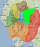
Area: EASTERN FELLS -
Sub-Marsh - 133 summits which are over 600 metres but fail the 30 metre drop from the four books by Terry Marsh: The Mountains of Wales (1985), The Lakes Mountains Vol 1 and 2 (1987) and The Pennine Mountains (1989) all published by Hodder & Stoughton. The list was defined by the original publication and is not subject to revision.
Members can use the list below as their personal Sub-Marsh bagging tick list. Just register and log in to tick them off...
Selected mapping: Google or Bing / Ordnance Survey
Map Legend: :Sub-Marsh | :Nearby Sub-Marsh
Sub-Marsh List & GPS Waypoints:
Climbed any of these hills? Log in to tick them off...
Sort this list by: Name | Height | Popularity | Prominence | Significance
- '0610.b' NY327176 Brown Crag (610m, p10)
- '0660.b' NY330211 Calfhow Pike (660m, p9)
- '0823.b' NY358120 Cofa Pike (823m, p13)
- '0612.b' NY373178 Heron Pike (Glenridding) (612m, p9)
- '0884.b' NY343136 High Crag (Grisedale) (884m, p8.7)
- '0614.-' NY384101 Little Hart Crag West Top (614m, p6.2)
- '0654.w' NY397095 Middle Dodd (654m, p14)
- '0644.s' NY390075 Snarker Pike (644m, p6)
- '0789.w' NY335195 Watson’s Dodd (789m, p11)
All these waypoints have been bagged by...
amblerbob Chris Jackson Chris Pearson chrisd101 citygent dave geere edgradwell IainT iwc jamesfc Jane T johnc Liz_N moorsman Nettle Graves Nick Wakelam nordicstar oakesave owaincaesarius Peebs Phil Newby rhw Ronnie Bowron snaithd Wanderer Wycombe Wanderer
Total = 9 Sub-Marsh in OS Area EASTERN FELLS