Lake District Sub-Dochartys - Sub Docharty - Docharty's objective was to list all points on the 1 inch O.S. Maps with a minimum requirement for a 'Top' being one 50-foot contour, for Ireland the minimum was one 100-foot contour. However Docharty decided that some of the heights marked on the map, which on being visited did not appear to have sufficient individuality to qualify as 'Tops' so these were included under a Remarks column in respect of Scotland and Ireland and a fifth column in respect of Wales and England for Part 1 and under a Remarks column for Part 2. None of these added through to Docharty�s Summary Tables.
Also included within subs are 'tops' or eminences unrecorded on the maps but identified by Docharty while on excursion.
The lists are defined by the original publications and is not subject to revision.
Each of the four constituents of the British Isles are included: Scotland 533 summits, Ireland 25, Wales 41 and England 89, totalling 688.
Sub-Docharty data courtesy of Ronnie Bowron
More information: /other/dochartys-hill-lists/
Members can use the list below as their personal Sub-Docharty bagging tick list. Just register and log in to tick them off...
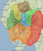
Selected mapping: Google or Bing / Ordnance Survey
Map Legend: :Sub-Docharty | :Nearby Sub-Docharty
Sub-Docharty List & GPS Waypoints:
Climbed any of these hills? Log in to tick them off...
Sort this list by: Name | Height | Popularity | Prominence | Significance
- '0901.-' NY224078 Blunt Top (901m, p10)
- '0891.N' NY343142 Nethermost Pike (891m, p29.1)
- '0884.b' NY343136 High Crag (Grisedale) (884m, p8.7)
- '0859.s' NY332156 Browncove Crags (859m, p3)
- '0823.b' NY358120 Cofa Pike (823m, p13)
- '0812.-' NY441114 High Street North Top (812m, p1)
- '0807.b' NY190206 Eel Crag (Birkett) (807m, p5)
- '0789.w' NY335195 Watson’s Dodd (789m, p11)
- '0784.b' NY372134 Gavel Pike (784m, p4)
- '0781.N' NY447125 Kidsty Pike (781m, p15)
- '0776.n' NY249057 Shelter Crags North Top (776m, p15.7)
- '0769.-' NY220069 Rough Crags West Top (769m, p11.7)
- '0765.-' NY458088 The Knowe (Harter Fell South Top) (765m, p1)
- '0756.n' NY187218 Sand Hill (756m, p17)
- '0700.-' NY215160 Hindscarth South Top (700m, p10)
- '0651.W' NY291339 Great Sca Fell (651m, p13)
- '0647.-' NY234164 Eel Crags (647m, p7.2)
- '0644.b' NY279071 Thorn Crag (644m, p9.7)
- '0634.n' NY236171 High Spy North Top (634m, p16)
- '0634.n' NY212141 Honister Crag (Black Star) (634m, p20.9)
- '0633.b' NY289342 Little Sca Fell (633m, p9)
- '0631.s' NY407165 Round How (631m, p6)
- '0627.b' NY310327 Coomb Height (627m, p6)
- '0621.-' NY210140 Fleetwith Pike East Top (621m, p7.6)
- '0617.H' NY175091 Yewbarrow North Top (Stirrup Crag) (617m, p33)
- '0616.N' NY310339 Great Lingy Hill (616m, p18)
- '0610.-' NY124165 Great Borne North Top (610m, p5)
- '0609.W' NY168049 Illgill Head (609m, p312)
- '0595.-' NY192132 Haystacks NW Top (595m, p1)
All these waypoints have been bagged by...
amblerbob chrisd101 IainT iwc nordicstar oakesave Peebs Ronnie Bowron snaithd thenomad
Total = 29 Sub-Docharty in Lake District