Lake District Sub-Nuttalls - Hills falling short of being Nuttalls on drop between 10m and 14.99m. Includes 41 of the 59 Deleted Nuttalls � the remainder are sub P10. This is an objective list with criterion and therefore subject to change as additional surveying data becomes available. List author Ronnie Bowron.
Thanks to Joe Nuttall for use of his JNSA data analysis as well as Aled Williams and Myrddyn Phillips for use of their LIDAR data analysis and Trimble GeoXH 6000 survey results from which this list is compiled. Thanks to John & Anne Nuttall for allowing a Sub Nuttall listing.
Members can use the list below as their personal Sub-Nuttall bagging tick list. Just register and log in to tick them off...
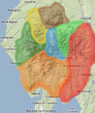
Selected mapping: Google or Bing / Ordnance Survey
Map Legend: :Sub-Nuttalls | :Nearby Sub-Nuttalls
Sub-Nuttall List & GPS Waypoints:
Climbed any of these hills? Log in to tick them off...
Sort this list by: Name | Height | Popularity | Prominence | Significance
- '0805.b' NY311270 Knowe Crags (Blease Fell) (805m, p14.7)
- '0840.b' NY250049 Crinkle Crags-Third Crinkle (Gunson Knott) (840m, p14)
- '0847.-' NY346149 Striding Edge (847m, p12.7)
- '0762.W' NY209050 Slight Side (762m, p14)
- '0735.-' NY220081 Round How East Top (735m, p13.7)
- '0690.W' NY244287 Ullock Pike (690m, p14.4)
- '0781.-' NY247105 Glaramara North Top (781m, p12.6)
- '0711.s' NY429110 Thornthwaite Crag North Top (711m, p13.8)
- '0856.-' NY210057 Long Green Scafell (856m, p11.3)
- '0739.W' NY437126 The Knott (High Street) (739m, p13)
- '0698.W' NY427117 Gray Crag (698m, p13.7)
- '0929.b' NY260288 Skiddaw Middle Top (929m, p10.1)
- '0665.b' NY340310 Tarn Crags Top (Bowscale Fell East Top) (665m, p14)
- '0808.-' NY236067 Pike de Bield East Top (808m, p11.5)
- '0654.w' NY397095 Middle Dodd (654m, p14)
- '0642.b' NY282314 Little Calva (642m, p14.2)
- '0769.-' NY220069 Rough Crags West Top (769m, p11.7)
- '0692.-' NY209099 Napes Needle (692m, p13)
- '0634.b' NY195234 Hobcarton End (634m, p14.1)
- '0717.-' NY281075 Harrison Stickle North Top (717m, p12.4)
- '0736.W' NY286088 Sergeant Man (736m, p12)
- '0789.w' NY335195 Watson’s Dodd (789m, p11)
- '0694.-' NY215080 Criscliffe Knotts (694m, p12.3)
- '0651.W' NY291339 Great Sca Fell (651m, p13)
- '0682.b' SD260965 Brown Pike (682m, p12)
- '0618.-' NY229092 Seathwaite Fell SE Top (618m, p13)
- '0760.W' NY447101 Mardale Ill Bell (760m, p10)
- '0755.b' NY412100 Caudale Moor-John Bell’s Banner (755m, p10)
- '0661.-' NY159099 Scoat Tarn Top (661m, p11)
- '0674.-' NY275073 Pike of Stickle East Top (674m, p10.6)
- '0674.w' NY266307 Bakestall (674m, p10.6)
- '0679.-' NY231086 Ruddy Gill Top (679m, p10.4)
- '0682.-' NY215081 Criscliffe Knotts East Top (682m, p10.4)
- '0613.-' NY227099 Seathwaite Fell North Top (613m, p11.4)
- '0616.-' NY356091 Rydal Fell 3rd Top (616m, p11)
- '0670.-' SD275988 Brim Fell (Raven Tor) (670m, p10)
- '0625.-' NY256113 Dovenest Top [Dovenest Crag] [Stonethwaite Fell] SE Top (625m, p10.4)
- '0634.-' NY228089 Sprinkling Tarn Top (634m, p10.1)
- '0626.b' NY473069 Goat Scar (626m, p10)
Total = 39 Sub-Nuttalls in Lake District