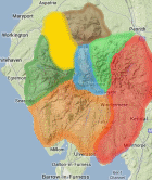
Area: NORTH WESTERN FELLS -
Sub-TuMPs - SubTumps - hills in Britain & Ireland with 20m-29.9m prominence irrespective of height. The list has been compiled by Bernie Hughes, and includes data originated by Myrddyn Phillips and Aled Williams. Source lists available at The Fours. Thanks also to https://MountainViews.ie/ for permission to include data from their lists.
Members can use the list below as their personal Sub-TuMP bagging tick list. Just register and log in to tick them off...
Selected mapping: Google or Bing / Ordnance Survey
Map Legend: :Sub-TuMPs | :Nearby Sub-TuMPs
Sub-TuMP List & GPS Waypoints:
Climbed any of these hills? Log in to tick them off...
Sort this list by: Name | Height | Popularity | Prominence | Significance
- '0510.w' NY195270 Broom Fell (510m, p28.9)
- '0241.-' NY174319 Elva Hill (241m, p29.8)
- '0124.-' NY252227 Fawe Park (124m, p23.5)
- '0100.-' NY244236 Hodgson How (100m, p22.9)
- '0704.N' NY184227 Ladyside Pike (704m, p29.2)
- '0174.-' NY154208 Lanthwaite Wood (174m, p24.4)
- '0245.-' NY247156 Lingy Bank (245m, p24.3)
- '0345.b' NY203296 Lothwaite (345m, p27)
- '0103.-' NY251233 Portinscale Hill (103m, p24.3)
- '0337.-' NY201299 Routenbeck Hill (337m, p20.9)
- '0096.-' NY259212 St Herbert’s Island (Derwent Water) (96m, p21)
- '0493.b' NY206253 Tarbarrel Moss (493m, p24)
Total = 12 Sub-TuMPs in OS Area NORTH WESTERN FELLS