The Wainwright Summits
Wainwright Summit Data Excel File
Introduction
The challenge of completing all 214 Wainwright summits as detailed in Alfred Wainwright set of Pictorial Guides is one of the most popular, if not the most popular hill bagging challenges in the UK.
The Pictorial Guides were not devised as a Hill Bagging List per se, moreover Wainwright was more about exploring each individual fell, Wainwright did devote a section of each chapter to the Summit area. As such it’s entirely appropriate that lovers of the Lake District want to visit each and every summit.
In the last decade technology has come to dominate our day to day lives and this is no different to exploring the Great Outdoors. GPS has taken over our navigation whether it’s via aeroplanes, boats, motor vehicles and now shank’s pony. Walking GPS’s whether via dedicated units or Apps on Mobile phones greatly improve the accuracy of navigation in the mountains and as a result improves safety for all.
The explosion of GPS units and Apps means there is a need for even greater data accuracy with GPS units requiring 10 figure Grid References which are accurate to 1 metre square.
“How do I find or create an accurate list of 10 figure Grid References for each Summit?” What appears to be a simple question has finished up with hundreds of hours of research over the last couple of years to arrive at a consolidated list.
The Issue
Within the UK the Database of British and Irish Hills (DoBIH) is regarded by most other hill bagging websites and hill list apps as the ‘golden source’ of their data feeds.
This leads to a fundamental issue as to the identification of the summit location between DoBIH and many (older) lists such as Wainwright: –
- The DoBIH define the Summit of a hill as a single point that is the highest natural ground above sea level (Ordnance Datum Newlyn in mainland Britain or Malin Head for all Ireland) on that hill.
- However as noted by DoBIH Wainwright’s preference was for a recognisable feature such as a Cairn, shelter of Trig Point. Wainwright did not use grid references to identify summit locations instead relying upon a combination of Summit sketch, Map identifying the summit location and Wainwright’s description of the summit area.
The importance of this distinction was not material when people used paper maps and six figure grid references as the rounding in the latter largely addressed the differences however with GPS units requiring much more accurate ten figure grid references the issue becomes more acute.
The DoBIH have sought to address these differences by adding a Note Field where differences between the true summit and the Wainwright summit are noted. This is fine if one is planning routes from the Hillbagging (and some other) websites but most Apps and other Hill Listings only take the data feed of the ten figure grid reference in DoBIH.
To illustrate the point let’s use an example of Gray Crag.
DoBIH/ Hill Bagging notes the true summit to be at NY 42756 11709 with a note “this is Nuttall summit S of wall; Wainwright summit is N of wall at NY 42672 11869”.
The excellent IOS App Hill Lists by Graham Haley lists Gray Crag summit location as NY 42756 11709.
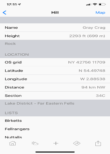
Highlighting this issue is not to disparage DoBIH or any of the websites/ apps that take data feeds but to highlight the key point that the latter (as they don’t take the Notes data feed) can be misleading as to the location of the Wainwright summit.
In this particular case, people often climb it as an out/ back from Thornthwaite Crag therefore may out on the Wainwright summit by not walking the extra 150 metres or so to the Wainwright summit position.
The object of this research was therefore to identify and highlight all those Wainwright summits that differ from the true summit location as defined in DoBIH to arrive at a more accurate ten figure grid reference for each Wainwright summit.
Identifying Wainwright summit positions
How did Wainwright chosen his 214 Fells and summit positions? This is a question that has always intrigued me and many others for that matter.
I have always related this question to Mark Jackson’s list of Relative Wainwrights (P30+) of the Lake District over 1000ft as described in the Long Distance Walkers Association (LDWA) Hillwalkers’ Register Annual Report of 2011. In using the UIAA definition of separate summits of P30+ Jackson’s excellent research removed 56 Wainwrights and added in 59 new Relative Wainwrights to arrive at his total of 217 Relative Wainwrights.
In percentage terms this is 26% of the 214 listing of which only five [Gray Stones, High Style, Seathewaite Fell, Whiteside and Whinlatter Top] can be explained away by there being a separately recognised higher top close by.
Even these additions/ deletion numbers are understated. The original list missed Gowbarrow Fell P100 and Rough Crags (Riggindale) P33. Later surveys after Jackson’s work was published would now add Silver How P31 upgraded May 2018, Striding Edge (High Spying How) P31.2 upgraded Sept 2018 and Wansfell Pike P30.8 upgraded Jun 2018. There would be others within Wainwright’s geographic definition of Lakeland from Book 1 which could also be considered.
Why such disparity between the two Wainwright lists? Why did Wainwright choose less significant fells over many more prominent summits?
The answer to these questions I believe largely rests in understanding the OS maps he had available to him when he was developing the idea of the Pictorial Guides. This will also explain many of the summit positions.
| 1947 | 1948 | 1949 | 1950 | 1951 | 1952 | 1953 | 1954 | 1955 | 1956 | |
| Wainwright Books |
Developed Idea |
Book 1 | ||||||||
| OS 6Th Series One Inch | 82, 83 88, 89 | |||||||||
| OS 7Th Series One Inch | 82 | 83, 88 89 | ||||||||
| 1957 | 1958 | 1959 | 1960 | 1961 | 1962 | 1963 | 1964 | 1965 | 1966 | |
| Wainwright Books | Book 2 | Book 3 | Book 4 | Book 5 | Book 6 | Book 7 | ||||
| OS 6Th Series One Inch | ||||||||||
| OS 7Th Series One Inch |
The above table shows the inter relationship timeline between researching the Pictorial Guides and the year of publication of each of the seven books. In the 1940/1960s the mapping of Lakeland was covered by four maps: –
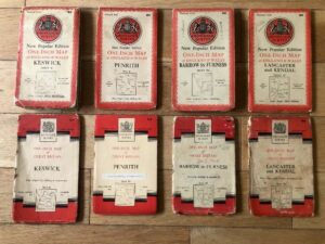
- Sheet 82 – Keswick
- Sheet 83 – Penrith
- Sheet 88 – Barrow in Furness
- Sheet 89 – Lancaster and Kendal
During these decades there were two series of One Inch maps published by the Ordnance Survey: –
- The 6th Series also known as the ‘New Popular Edition’
- The 7th Series
Whist the 7th Series was available by the time Book 1 was published in 1955, the vast majority of the research period for the Pictorial Guides would have been covered by the New Popular Edition. That is not to discount that Wainwright did not use the 7th Series particularly in latter books – there are examples in Wainwright’s commentary that could only have come from 7th Series mapping.
Also there are references in the Pictorial Guides to 2 ½ Inch Mapping for example in the chapters for Sheffield Pike, Southern Fell and Stybarrow Dodd which are available on the National Library of Scotland website as 1:25,000 1937-61.
There is a vitally important difference between the 6th and 7th Series in relation to what we now regard as the Trig symbol:
The 6th Series mapping used the Trig symbol to identify the old Trig Station positions that was a carry forward from the Six Inch mapping of the late 1800’s.
However in the 7th Series the Trig symbol was changed to represent the Trig Pillars we know on current OS mapping. The first Trig Pillar in the UK was built in 1936.
To understand Wainwright’s choice of Fells and many of the summit positions one needs to understand the work of the OS surveyors of the late 1880’s. These surveyors used Trig Stations to map the UK to what is still regarded as an incredible degree of accuracy. As per Trig Pillars, a Trig Station needed to be in line of sight of at least another two Trig Stations. So more often that not these Trig stations were not on the true summit of a Fell but on ridge ends for better sight lines.
To allow the OS Surveyors to return to the same spot to continue their survey work these Trig Stations were very often marked by a CAIRN.
We know from his work that Wainwright was a highly visual person and secondly he liked to a ‘The View’ 3560 degrees spiral in many chapters. Therefore both the OS Surveyors and Wainwright wanted the same locations – positions with excellent surrounding views.
Let me show three example to demonstrate this thesis: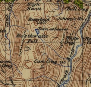
Rosthwaite Fell – Bessyboot. The New Popular Edition mapping shows the Trig Station 1,807ft at Bessyboot although Wainwright could have chosen the higher 2,000ft contour circle on Rosthwaite Fell.
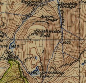 Seathwaite Fell – again Wainwright used the Trig Station 1,970ft position rather than the 2,050-contour circle of the true summit.
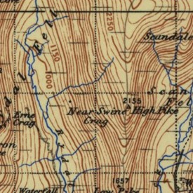 High Pike (Scandale) – this is only a P6 and an example of a ridge end Trig Station.
On the 6th Series mapping there are 182 Trig Stations related to Wainwright Fells plus seven Benchmarks lead by Scoat Fell at the famous cairn in the wall. But a word of caution, Wainwright was not consistent in using Trig Station positions over true summit positions where sometimes he went for the latter: –
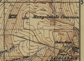 Mungrisdale Common – the Trig Station 2,038 is well off the summit plateau.
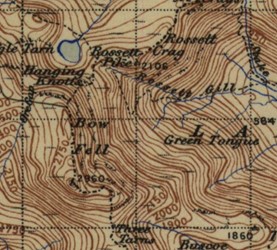 Rossett Pike – the Trig Station is at Mickleden Cairn (a far better view) but Wainwright used the cairn at the Benchmark (a boundary corner) with a height of 2,134.2 ft.
Data Accuracy
How accurate should the GR10 be?
A 10-figure GR10 is suitable for input to most hand-held GPS instruments.
Three independent studies have shown that the error in on the ground measurements has been determined as ±8.5m (three standard deviations), with the majority accurate to within ±5m of the summit feature. Any measurements with survey grade GPS receivers (indicated in the Survey field) will be accurate to 1m.
Different brands on GPS units may result in slightly different readings depending on their software and atmospheric conditions may mean data accuracy of 3 to 5 metres.
I am 99% confident that the GR10s are accurate to within 5 metres given the vagaries of a) GPS unit error b) the minor difference between OSGB36/ WGS84 datum and the fact many cairns are more than one metre wide. The GR10’s are based on WGS84 as the dominant mapping datum globally both in mobile phones/ Satnav systems and mapping websites.
Group A
Where the Wainwright summit is a different recognised summit from the summit recorded on DoBIH. There are five summits in this group.
| Glaramara | GR: NY 24719 10563 | ||
| Hill Name | Glaramara North Top | DoBIH Name | Glaramara |
| Hill ID | 500023 | DoBIH Number | 2389 |
| Height | 781m / 2562ft | Height | 783m / 2569ft |
| Summit Feature | Rocky platform bearing two Cairns | Summit Feature | pointed rock 10m south of Cairn |
| GR10 | NY 24719 10563 | GR10 | NY 24600 10456 |
Note DoBIH Observation: “Nuttall summit; Wainwright summit (Cairn) 160m NE at NY 24722 10561 and Cairn 55m W are lower”.
Pointers to the Wainwright summit position from the Pictorial Guide:
The sketch map shows the summit position as the southern of two Cairns on the North East Top. This ties in with latest OS mapping
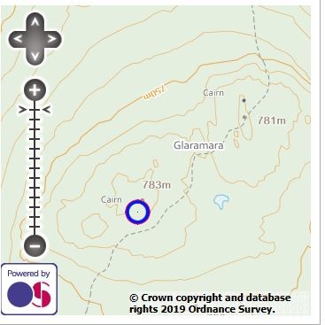
Wainwright states “Twin summits of rock…. but indisputably the finer is that to the north east…bearing two Cairns”.
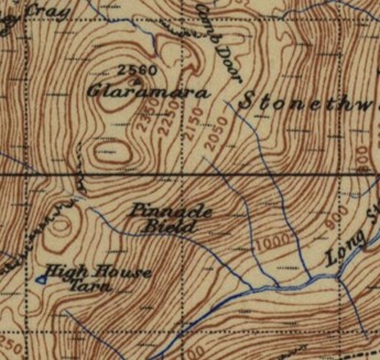 Sixth Series New Popular Edition shows a 2,550 contour in the north east of the 2,500 contour. The separate 780 metre contour south west should have had a second 2,550 ft contour.
The Se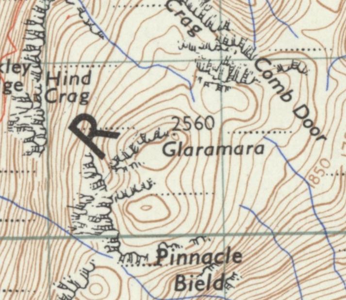 venth Series has a similar ‘error’ but now dropping the Trig Station to a Spot Height on the North Top.
Old Imperial mapping did not recognise the current true summit of Glaramara and as such various Hill Bagging Lists identified Glaramara North Top as the summit of Glaramara: Corbett25, Docharty, Falkingham, Moss2000 and Simpson.
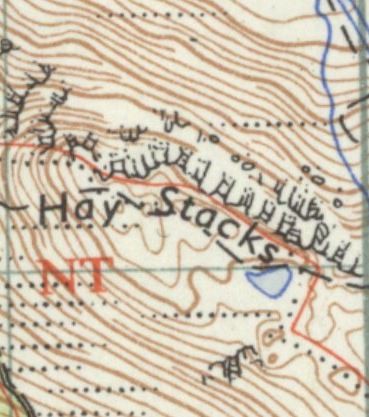
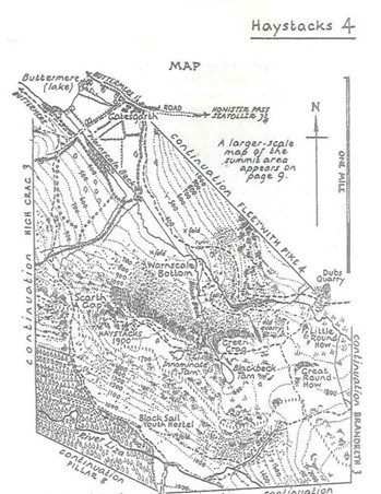
| Haystacks (Buttermere) | GR: NY 19336 13204 | ||
| Hill Name | Haystacks North Top | DoBIH Name | Haystacks (Buttermere) |
| Hill ID | 501446 | DoBIH Number | 2457 |
| Height | 595m / 1952ft | Height | 597m / 1959ft |
| Summit Feature | Cairn | Summit Feature | Cairn |
| Grid Reference | NY 19336 13204 | Grid Reference | NY 19335 13151 |
Note DoBIH Observation: “Wainwright/Birkett is Cairn 50m north at NY 19336 13204”.
Pointers to the Wainwright summit position from the Pictorial Guide:
The Wainwright sketch map shows the summit position as the northern of two Cairns.
Spot Height of 1,900 feet approx. – no OS Spot Height but instead twin 1,900 feet contour circles.
Wainwright states “The highest part of the fell is a small rocky ridge, fifty yards in length, with a Cairn at each end, and a tarn alongside to the west. The two Cairns are at approximately the same elevation, but the north one, lying on the line of the path across the top of the fell, is usually reckoned to be the true summit”.
The summit sketch shows a metal stake extending from the summit Cairn. This is still there.
Modern surveying equipment now show the southern Cairn as the true summit but Wainwright sits alongside Birkett and Docharty in declaring the Northern Cairn as the summit.
Interestingly Docharty is the only known hill list author to declare twin summits here recognising the second 1,900 foot contour circle in his research work.
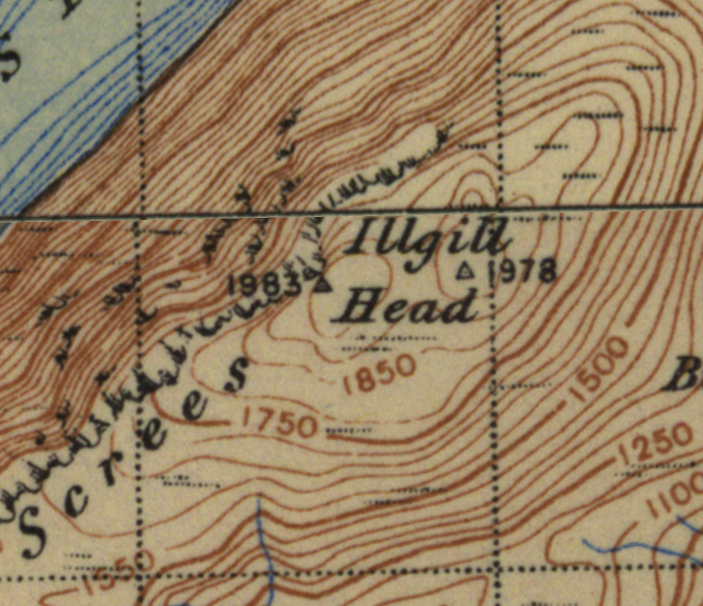
| Illgill Head | GR: NY 16542 04804 | ||
| Hill Name | Illgill Head (Docharty summit) | DoBIH Name | Illgill Head |
| Hill ID | 501445 | DoBIH Number | 2454 |
| Height | 604m / 1982ft | Height | 608.8m / 1997ft |
| Summit Feature | Cairn | Summit Feature | rock |
| Grid Reference | NY 16542 04804 | Grid Reference | NY 16898 04924 |
Note DoBIH Observation: “Wainwright summit is a Cairn at NY165048 which is at least 3m lower than true summit”.
Pointers to the Wainwright summit position from the Pictorial Guide:
The Wainwright sketch map shows the summit position at the western end of the summit contour overlooking the Wasdale Screes.

The spot Height of 1,983 feet ties into the western of the two Trig Stations. The old OS maps incorrectly showed the Wainwright summit as the higher of the two spot heights on Illgill Head
| Low Fell | GR: NY 13597 22264 | ||
| Hill Name | Loweswater Fell (Low Fell) | DoBIH Name | Low Fell |
| Hill ID | 3780 | DoBIH Number | 2493 |
| Height | 412m / 1352ft | Height | 423m / 1388ft |
| Summit Feature | Cairn on rock | Summit Feature | ground by small Cairn |
| Grid Reference | NY 13597 22264 | Grid Reference | NY 13732 22616 |
Note DoBIH Observation: “An alternative location for the Wainwright is the south top at NY136223 (412m)”
Pointers to the Wainwright summit position from the Pictorial Guide:
The Wainwright sketch map shows the summit position at the southern end of the 1,300 feet contour circle but Low Fell 5 also references “map shows ‘1350’ contours at both places”.
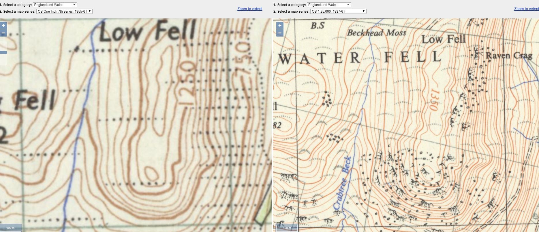 Wainwright states “The most southerly eminence has the main Cairn” and “two Cairns 100 and 120 yards southeast of the main Cairn indicate better viewpoints”.
The Wainwright sketch map indicates the summit is south of the wall and ties into the 1:25k mapping from 1937-61.
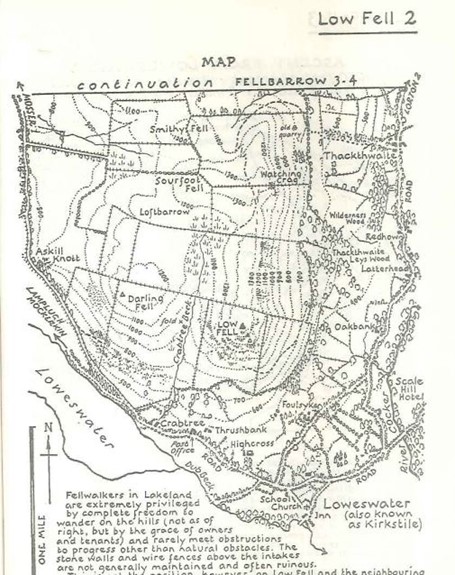
The summit page also has a separate smaller sketch entitled ‘Cairn on the north top’.
Wainwright estimated the summit height as approx. 1360’ which is much closer to the Loweswater Fell current height than Low Fell.
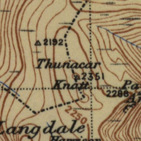
| Thunacar Knott | GR: NY 27909 08136 | ||
| Hill Name | Thunacar Knott North Top | DoBIH Name | Thunacar Knott |
| Hill ID | 500026 | DoBIH Number | 2413 |
| Height | 715m / 2346ft | Height | 723m / 2372ft |
| Summit Feature | Cairn | Summit Feature | rock 3m NNE of Cairn |
| Grid Reference | NY 27909 08136 | Grid Reference | NY 27975 07992 |
Note DoBIH Observation: None relating to Wainwright summit location.
Pointers to the Wainwright summit position from the Pictorial Guide:
The Wainwright sketch map shows the summit position north of a small tarn.
Wainwright states “The recognised summit, surmounted by a well-made Cairn, is a mound north of the tarn; the benchmark height is 2351’”. This ties in with the mapping of the era with the 2351’ Spot Height on the northern summit.
Group B
Some 46 Wainwright summits which are greater than 10 metres from the current true summit recorded in the DoBIH. The average deviation (excluding Mellbreak see note) is 63.6 metres. With Mellbreak the average deviation is 84.4 metres.
Ahead of detailing the full list four summits deserve special mention as there have been considerable doubts as to the correct Wainwright summit position.
Dodd
Of all the Wainwright summits Dodd has changed the most from Wainwright’s era although the historic forestry remains are still there for all to view. Wainwright’s sketch was of a cairn in a small clearing on tussocky grass surrounded by Pinus mugo, the mountain pine.
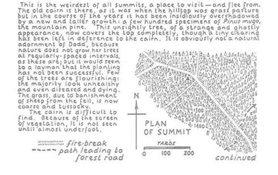
Wainwright described the cairn as “twenty yards from the fire break” as part of the descent route description. His attention to detail on the forest trails and fire breaks helps unlock the Wainwright summit position. Using Google Earth and satellite photos most of the fire break lines drawn by Wainwright can still be seen as can be plotted as follows: –
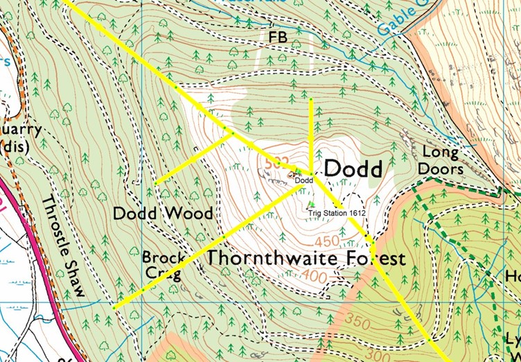
On the strong balance of probabilities, the Dodd (Skiddaw) true summit position is most likely to be the same as the Wainwright summit position. Interestingly, whilst Wainwright used the Trig Station height for Dodd’s height in this case he didn’t use it for the summit. The Trig Station would have predated the forestry and is again an excellent view point for surveying.
The distinctive summit cairn rocks (long thin slate) as drawn by Wainwright are in the locality but not in the correct position. At the time of my last visit in 2019 they had regrettably been used by wild campers as part of a fire.
Mellbreak
Mellbreak with its North and South tops both recognised uniquely by Wainwright in his sketch Map on Mellbreak 3 – is this the 215th Wainwright?
 On the OS 6th Series New Popular Edition mapping Wainwright would have noted Trig Stations on both the north and south tops hence the double summit markers.
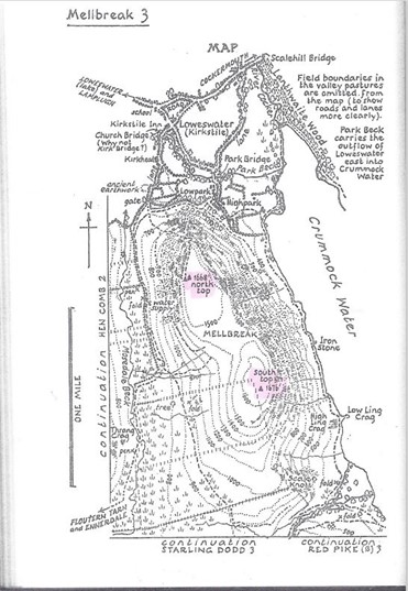 Additionally, on the north top Wainwright sketched a cairn triangle marker (not coloured in, a magnifying glass is useful here) to the South West of the Trig Station.
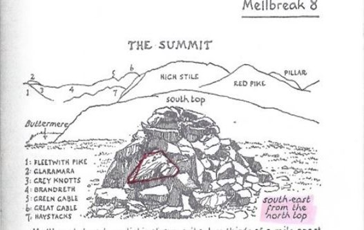 The Wainwright summit sketch is of a cairn with a description “south-east from the north top”, behind the cairn Wainwright sketched and named outlines of various fells including the South Top. He also commented “The more attractive of the two is the heathery north top” and “An odd thing about both summits is that the cairn on each is not quite on the highest ground”. Wainwright’s attention to detail is second to none and within the summit cairn is an unusually shaped rock with horizonal strata.
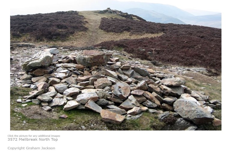
Wainwright’s attention to detail is second to none and within the summit cairn is an unusually shaped rock with horizonal strata which is outlined in red. I am indebted to Graham Jackson for this Mellbreak North Top summit photo above. On the left of the cairn is a light-coloured rock of very similar shape and horizonal strata to that detailed in the Wainwright sketch.
All this evidence points to the Wainwright summit of Mellbreak being a cairn 34m North East of Mellbreak North Top true summit. This is the 1,668ft Trig Station at NY 14324 19495.
Sale Fell
The doubts over Sale Fell relate to the ‘cairn [as] described by Wainwright and Birkett has been largely destroyed’ particularly as there is little by way of cairn rocks in the immediate area. As others have pointed out cairns come and go so the true summit may well be the Wainwright summit.
This required a site visit to test my theory.
There are two keys to resolving the doubts: –
- The 1,170ft Trig Station position from Six Inch mapping at NY 19461 29712.
- The ascent route from Bassenthwaite Lake Station as described by Wainwright.
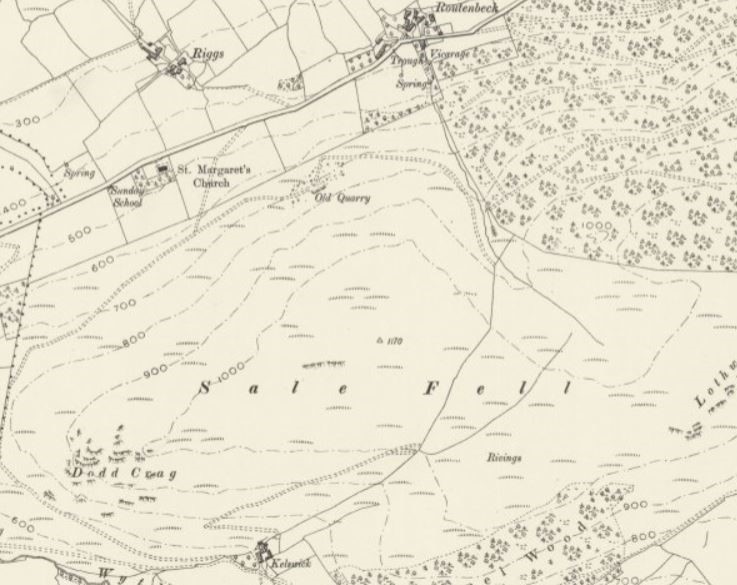
Wainwright described within the route that “Upon reaching a broken wall turn right up the fell”.
This follows a natural ridge line up the fell until you arrive at the summit area and directly at the Trig Station cairn. The cairn itself is an embedded rock with loose rocks on top. As with many Trig Station positions of the late 1800’s it is not at the highest point but instead on a ridge end with excellent views.
Also the cairn is slightly on a down slope so is out of sight from the true summit position.
Once again we are indebted to Wainwright’s attention to detail in his summit drawing. The two largest rocks, a rectangle shaped rock in the bottom right hand corner and a second rock above and left which appears to be two rocks but instead an indented rock are both still in the depleted summit cairn.
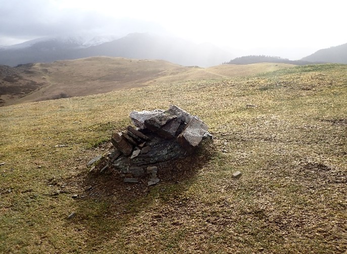
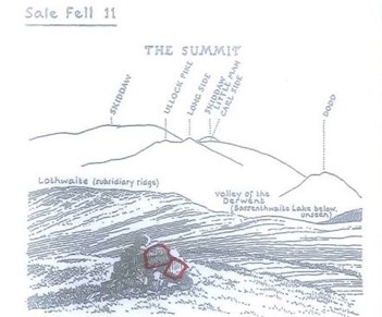
The panorama lines up perfectly with Wainwright’s summit drawing of Lothwaite and the Skiddaw range behind.
The Wainwright summit cairn of Sale Fell is at NY 19461 29711.
Sour Howes
Given it’s triangle shaped flat summit plateau with lot’s of grass hummocks it’s one of the most difficult to identify the true summit never mind the Wainwright summit. So much so on my last visit everyone I observed missed the true summit and went to what appears to be a more obvious summit.
The DoBIH Observation is “Wainwright’s summit is probably shaly ridge 60m ESE NY 42832 03198; Wainwright’s sketch map may be misleading as it indicates summit is further SW where ground is obviously lower”.
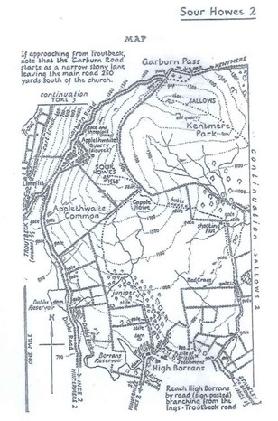
My contention is that Wainwright’s map is not misleading in the light of the Six Inch and particularly the Sixth Series mapping available at the time.
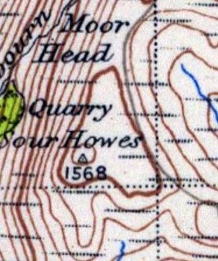
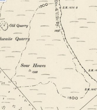
The OS clearly believed that the highest point was in the 1,550ft contour circle in the SW corner of the summit plateau.
The old Trig Station is spotted at NY 42660 03156 from Six Inch mapping.
Following a site visit the Trig Station position is indeed a grassy hummock and the highest point on the western side of the fell. The Wainwright summit sketch can be matched up with the foreground, a flat summit and sloping ground on the right side and the background fells as described by Wainwright.
The Wainwright summit of Sour Howes is at NY 42660 03156.
| Bakestall | GR: NY 26631 30857 | ||
| Wainwright Summit Feature | Cairn | True
Summit Feature |
Cairn near fence |
| Deviation | 111m | DoBIH GR10 | NY 26642 30747 |
| Bannerdale Crags | GR: NY 33609 29076 | ||
| Wainwright Summit Feature | Cairn | DoBIH
Summit Feature |
rock 3m NE of pile of stones |
| Deviation | 94m | DoBIH GR10 | NY 33530 29026 |
| Birks | GR: NY 38177 14485 | ||
| Wainwright Summit Feature | Cairn | DoBIH
Summit Feature |
no feature: grass mound |
| Deviation | 203m | DoBIH GR10 | NY 38020 14357 |
| Bleaberry Fell | GR: NY 28566 19576 | ||
| Wainwright Summit Feature | windshelter
|
DoBIH
Summit Feature |
rock 10m E of windshelter |
| Deviation | 11m | DoBIH GR10 | NY 28577 19577 |
| Brandreth | GR: NY 21487 11930 | ||
| Wainwright Summit Feature | Cairn | DoBIH
Summit Feature |
rock |
| Deviation | 36m | DoBIH GR10 | NY 21454 11916 |
| Broom Fell | GR: NY 19441 27191 | ||
| Wainwright Summit Feature | tall cairn | True
Summit Feature |
no feature: heather |
| Deviation | 174m | DoBIH GR10 | NY 19544 27051 |
| Caw Fell | GR: NY 13192 11003 | ||
| Wainwright Summit Feature | Cairn | DoBIH
Summit Feature |
rock 13m E of Cairn |
| Deviation | 19m | DoBIH GR10 | NY 13210 10996 |
| Crag Hill [Eel Crag] | GR: NY 19266 20364 | ||
| Wainwright Summit Feature | trig point | DoBIH
Summit Feature |
no feature 35m S of trig point |
| Deviation | 32m | DoBIH GR10 | NY 19274 20333 |
| Dale Head | GR: NY 22304 15326 | ||
| Wainwright Summit Feature | large Cairn | DoBIH
Summit Feature |
no feature 18m W of large Cairn |
| Deviation | 15m | DoBIH GR10 | NY 22289 15325 |
| Fellbarrow – Mosser Fell | GR: NY 13220 24247 | ||
| Wainwright Summit Feature | trig point | DoBIH
Summit Feature |
no feature: ground 20m SE of trig point |
| Deviation | 23m | DoBIH GR10 | NY 13240 24235 |
| Gavel Fell | GR: NY 11695 18382 | ||
| Wainwright Summit Feature | Cairn | DoBIH
Summit Feature |
No feature |
| Deviation | 123m | DoBIH GR10 | NY 11657 18499 |
| Grange Fell [Brund Fell] | GR: NY 26408 16240 | ||
| Wainwright Summit Feature | Cairn on rock tower | DoBIH
Summit Feature |
Cairn on rock tor |
| Deviation | 67m | DoBIH GR10 | NY 26468 16276 |
| Gray Crag | GR: NY 42669 11870 | ||
| Wainwright Summit Feature | Cairn | DoBIH
Summit Feature |
rock |
| Deviation | 183m | DoBIH GR10 | NY 42756 11709 |
| Great Borne | GR: NY 12389 16382 | ||
| Wainwright Summit Feature | Trig Point | DoBIH
Summit Feature |
rock |
| Deviation | 24m | DoBIH GR10 | NY 12394 16358 |
| Great Dodd | GR: NY 34270 20451 | ||
| Wainwright Summit Feature | Cairn/ shelter | DoBIH
Summit Feature |
no feature: ground 30m SSE of Cairn |
| Deviation | 102m | DoBIH GR10 | NY 34204 20529 |
| Great Rigg | GR: NY 35581 10396 | ||
| Wainwright Summit Feature | Cairn | DoBIH
Summit Feature |
rock 15m NE of Cairn |
| Deviation | 16m | DoBIH GR10 | NY 35592 10406 |
| Grey Crag [Sleddale Fell] | GR: NY 49711 07176 | ||
| Wainwright Summit Feature | Cairn | DoBIH
Summit Feature |
rocky outcrop |
| Deviation | 44m | DoBIH GR10 | NY 49714 07220 |
| Hart Crag | GR: NY 36902 11208 | ||
| Wainwright Summit Feature | Cairn | DoBIH
Summit Feature |
outcrop |
| Deviation | 100m | DoBIH GR10 | NY 36818 11262 |
| Hart Side | GR: NY 35889 19734 | ||
| Wainwright Summit Feature | Cairn (western)
|
DoBIH
Summit Feature |
rock within 20m of 2 Cairns |
| Deviation | 14m | DoBIH GR10 | NY 35902 19729 |
| High Raise [High Raise (High White Stones)] | GR: NY 28076 09528 | ||
| Wainwright Summit Feature | Cairn due South of Trig Pillar | DoBIH
Summit Feature |
rock 15m SSE of trig point |
| Deviation | 14m | DoBIH GR10 | NY 28089 09523 |
| Holme Fell | GR: NY 31531 00657 | ||
| Wainwright Summit Feature | Cairn on large rock outcrop | DoBIH
Summit Feature |
rock 60m SSW of Cairn |
| Deviation | 57m | DoBIH GR10 | NY 31503 00605 |
| Ill Bell | GR: NY 43656 07721 | ||
| Wainwright Summit Feature | Cairn (centre of three) at Trig Station | DoBIH
Summit Feature |
N of two large cairns 30m apart |
| Deviation | 32m | DoBIH GR10 | NY 43649 07752 |
| Latrigg | GR: NY 27845 24659 | ||
| Wainwright Summit Feature | Green sward, top of path from south | DoBIH
Summit Feature |
Ground by path |
| Deviation | 87m | DoBIH GR10 | NY 27922 24699 |
| Ling Fell | GR: NY 17959 28593 | ||
| Wainwright Summit Feature | Trig Pillar | DoBIH
Summit Feature |
no feature |
| Deviation | 68m | DoBIH GR10 | NY 17994 28535 |
| Loadpot Hill | GR: NY 45726 18083 | ||
| Wainwright Summit Feature | Boundary Stone | DoBIH
Summit Feature |
no feature: ground 80m SW of trig point |
| Deviation | 97m | DoBIH GR10 | NY 45636 18046 |
| Lonscale Fell | GR: NY 28537 27173 | ||
| Wainwright Summit Feature | Cairn (extension of wall line) | DoBIH
Summit Feature |
no feature: ground 25m S of Cairn |
| Deviation | 30m | DoBIH GR10 | NY 28545 27144 |
| Maiden Moor | GR: NY 23668 18203 | ||
| Wainwright Summit Feature | Cairn | DoBIH
Summit Feature |
no feature |
| Deviation | 18m | DoBIH GR10 | NY 23677 18188 |
| Meal Fell | GR: NY 28258 33711 | ||
| Wainwright Summit Feature | large shelter | DoBIH
Summit Feature |
small Cairn |
| Deviation | 68m | DoBIH GR10 | NY 28301 33763 |
| Mellbreak | GR: NY 14324 19495 | ||
| Wainwright Summit Feature | Cairn at 1,668ft Trig Station on North Top | DoBIH
Summit Feature |
flat rock |
| Deviation | 1020m | DoBIH GR10 | NY 14843 18613 |
| Nethermost Pike | GR: NY 34407 14156 | ||
| Wainwright Summit Feature | Cairn 100 yards NE of circular wall | DoBIH
Summit Feature |
cairn |
| Deviation | 74m | DoBIH GR10 | NY 34367 14217 |
| Rampsgill Head | GR: NY 44224 12772 | ||
| Wainwright Summit Feature | Cairn | DoBIH
Summit Feature |
rock |
| Deviation | 147m | DoBIH GR10 | NY 44333 12871 |
| Rest Dodd | GR: NY 43268 13700 | ||
| Wainwright Summit Feature | Cairn | DoBIH
Summit Feature |
grass mound |
| Deviation | 55m | DoBIH GR10 | NY 43256 13646 |
| Robinson | GR: NY 20177 16873 | ||
| Wainwright Summit Feature | Cairn (W) | DoBIH
Summit Feature |
rock |
| Deviation | 16m | DoBIH GR10 | NY 20193 16872 |
| Sale Fell | GR: NY 19461 29712 | ||
| Wainwright Summit Feature | Cairn | DoBIH
Summit Feature |
embedded rock in grass |
| Deviation | 51m | DoBIH GR10 | NY 19445 29664 |
| Scar Crags | GR: NY 20749 20600 | ||
| Wainwright Summit Feature | Cairn | DoBIH
Summit Feature |
Cairn |
| Deviation | 118m | DoBIH GR10 | NY 20849 20662 |
| Scoat Fell | GR: NY 15951 11382 | ||
| Wainwright Summit Feature | Cairn on wall | DoBIH
Summit Feature |
Rock N of wall |
| Deviation | 16m | DoBIH GR10 | NY 15941 11394 |
| Seat Sandal | GR: NY 34387 11518 | ||
| Wainwright Summit Feature | Cairn | DoBIH
Summit Feature |
rock on knoll by ruined wall |
| Deviation | 35m | DoBIH GR10 | NY 34420 11530 |
| Seatallan | GR: NY 13942 08407 | ||
| Wainwright Summit Feature | large Cairn/ tumulus
|
DoBIH
Summit Feature |
no feature: ground 12m SSW of small Cairn |
| Deviation | 71m | DoBIH GR10 | NY 14003 08443 |
| Selside Pike | GR: NY 49074 11181 | ||
| Wainwright Summit Feature | Wind shelter | DoBIH
Summit Feature |
grassy rise with embedded rocks 40m SSW of wind shelter |
| Deviation | 38m | DoBIH GR10 | NY 49062 11145 |
| Sour Howes | GR: NY 42660 03156 | ||
| Wainwright Summit Feature | grassy hummock | DoBIH
Summit Feature |
grassy hummock |
| Deviation | 121m | DoBIH GR10 | NY 42765 03217 |
| Stony Cove Pike [Caudale Moor] | GR: NY 41864 09998 | ||
| Wainwright Summit Feature | Cairn | DoBIH
Summit Feature |
rock |
| Deviation | 82m | DoBIH GR10 | NY 41782 10006 |
| Thornthwaite Crag | GR: NY 43136 10008 | ||
| Wainwright Summit Feature | Beacon | DoBIH
Summit Feature |
rock 45m N of beacon |
| Deviation | 44m | DoBIH GR10 | NY 43150 10050 |
| Troutbeck Tongue | GR: NY 42231 06388 | ||
| Wainwright Summit Feature | Cairn | DoBIH
Summit Feature |
grassy knoll |
| Deviation | 40m | DoBIH GR10 | NY 42240 06427 |
| Ullock Pike | GR: NY 24425 28799 | ||
| Wainwright Summit Feature | Heather dome with crags to west | DoBIH
Summit Feature |
rock |
| Deviation | 44m | DoBIH GR10 | NY 24442 28759 |
| Walla Crag | GR: NY 27664 21286 | ||
| Wainwright Summit Feature | Cairn 60 yards from gate | DoBIH
Summit Feature |
Rock by cairn |
| Deviation | 20m | DoBIH GR10 | NY 27686 21287 |
| Wether Hill | GR: NY 45569 16781 | ||
| Wainwright Summit Feature | Cairn | DoBIH
Summit Feature |
no feature: rough grass |
| Deviation | 30m | DoBIH GR10 | NY 45597 16767 |
Group C
These Wainwright summits are correct in DoBIH but worth noting as an alternative true summit with the same/ similar name is close by. Important not to get the summits confused when bagging the Wainwright summit.
| Armboth Fell | |||
| Wainwright | Alternative Summit | ||
| Wainwright Name | Armboth Fell | Alternative summit name | Armboth Fell (Birkett) |
| Wainwright Summit Feature | rocky mound | DoBIH
Summit Feature |
large smooth outcrop |
| Wainwright GR | NY 29581 15739 | DoBIH GR10 | NY 29679 15968 |
| Height | 475m / 1558ft | Height | 480m / 1575ft |
| Brock Crags | |||
| Wainwright | Alternative Summit | ||
| Wainwright Name | Brock Crags (Wainwright) | Alternative summit name | Brock Crags |
| Wainwright Summit Feature | large cairn | DoBIH
Summit Feature |
no feature: large grassy mound |
| Wainwright GR10 | NY 41666 13660 | NY 41903 13699 | |
| Height | 561.2m / 1841ft | Height | 564.3m (1851ft) |
| Gibson Knott | |||
| Wainwright | Alternative Summit | ||
| Wainwright Name | Gibson Knott | Alternative summit name | Horn Crag |
| Wainwright Summit Feature | Cairn on rocky outcrop | DoBIH
Summit Feature |
Ground by cairn |
| Wainwright GR10 | NY 31689 10036 | DoBIH GR10 | NY 31855 09924 |
| Height | 420.1m / 1,378ft | Height | 421.9m / 1,384ft |
| Gowbarrow Fell | |||
| Wainwright | Alternative Summit | ||
| Wainwright Name | Gowbarrow Fell (Wainwright summit) | Alternative summit name | Gowbarrow Fell |
| Wainwright Summit Feature | trig point | DoBIH
Summit Feature |
embedded rock |
| Wainwright GR10 | NY 40761 21821 | DoBIH GR10 | NY 40731 21722 |
| Height | 481.2m / 1579ft | Height | 481.2m / 1579ft ** |
** NB: the Wainwright summit hill (rock 3m SE of trig point) is 1cm lower hence no difference in height quoted due to rounding.
| Graystones | |||
| Wainwright | Alternative Summit | ||
| Wainwright Name | Graystones | Alternative summit name | Graystones (Birkett) |
| Wainwright Summit Feature | small cairn on rocky outcrop | DoBIH
Summit Feature |
no feature |
| Wainwright GR | NY 17614 26622 | DoBIH GR10 | NY 17783 26420 |
| Height | 450.4m / 1478ft | Height | 455.3m / 1494ft |
| High Stile | |||
| Wainwright | Alternative Summit | ||
| Wainwright Name | High Stile | Alternative summit name | High Stile (Grey Crag – High Stile) |
| Wainwright Summit Feature | large cairn | DoBIH
Summit Feature |
small cairn |
| Wainwright GR | NY 16738 14792 | DoBIH GR10 | NY 17009 14817 |
| Height | 806m / 2644ft | Height | 807m / 2648ft |
| Rosthwaite Fell – Bessyboot | |||
| Wainwright | Alternative Summit | ||
| Wainwright Name | Rosthwaite Fell – Bessyboot | Alternative summit name | Rosthwaite Fell (Rosthwaite Cam) |
| Wainwright Summit Feature | Cairn | DoBIH
Summit Feature |
rock tor |
| Wainwright GR | NY 25829 12480 | DoBIH GR10 | NY 25586 11828 |
| Height | 551m / 1808ft | Height | 612m / 2008ft |
| Seathwaite Fell | |||
| Wainwright | Alternative Summit | ||
| Wainwright Name | Seathwaite Fell (Wainwright summit) | Alternative summit name | Seathwaite Fell (Great Slack – Seathwaite Fell) |
| Wainwright Summit Feature | Cairn | DoBIH
Summit Feature |
Cairn on rock |
| Wainwright GR | NY 22901 10183 | DoBIH GR10 | NY 22736 09710 |
| Height | 601m / 1972ft | Height | 632m / 2073ft |
| Wansfell | |||
| Wainwright | Alternative Summits | ||
| Wainwright Name | Baystones [Wansfell] | Alternative summit name 1 | Wansfell (Baystones) |
| Wainwright Summit Feature | Cairn | DoBIH
Summit Feature |
no feature: mound |
| Wainwright GR | NY 40316 05143 | DoBIH GR10 | NY 40356 05275 |
| Height | 486.9m / 1597ft | Height | 486.1m / 1595ft |
| Alternative summit name 2 | Wansfell Pike | ||
| DoBIH
Summit Feature |
outcrop 6m S of fence | ||
| DoBIH GR10 | NY 39416 04169 | ||
| Height | 484.3m / 1589ft | ||
In respect of Wansfell, the Wainwright summit is the true summit in this area. The naming conventions between Wansfell and Baystones makes it confusing. Also, some people confuse Wansfell with Wansfell Pike at the south western end of the ridge mainly because it’s the visible summit from Ambleside.
Author – Ron Bowron
Author: Phil Newby

This is fantastic work!
Hi,
This is a great resource! Thanks for sharing this.
I was wondering if Hart Crag should not also be in Group B? The true summit coordinates from DoBIH are 54.492752, -2.976954 whereas the Wainwright summit cairn (same height as ‘true’ summit) is located somewhere around 54.492268, -2.975574.
This is an incredible piece of work of which you should be very proud. I refer to it all the time as I endeavour to bag the Wainwrights.