Skip to content

Phil's Hiking Resources

Website Change Log

Wainwright’s Sub-Areas for all our Lake District Hills  

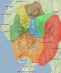
We have added new menu options for all the hills, tumps & synges in the Lake District. The Relative Hills of Britain (or Marilyn) area number 34 is now sub-divided into 7 extended areas based on Wainwright’s Books and colour coded accordingly. The new menu will display for all Wainwrights, Birketts and Synges, as well » read more »

Combining hills from two different bagging lists  

Adding two lists together As well as searching for hills based on their bagging type (specified by the “?list=” URL filter), a second hill type filter can be added (as “&list2=“) to give the total listing of two types of hill. This is the equivalent of adding the two lists together or the “union” of the two sets. For » read more »

Bagging Synges  

The 646 hills listed in Tim Synge’s book The Lakeland Summits can now be viewed (and ticked off) as a list here  http://www.haroldstreet.org.uk/waypoints/download/synges/ Although there is a substantial overlap between Birkett’s and Synge’s lists, Synge covers the whole of the National Park in a more comprehensive way (he includes 134 non-Birkett summits, many of them in » read more »

Filtering Hills: List all Hills in any given area  

In addition to being able to filter all the hills in any given 100km OS Map area like this: www.haroldstreet.org.uk/waypoints/download/?area=NY we’ve now also added functionality so you can list the hills in any rectangular area between two grid references like this… For 6 figure grid-references…  www.haroldstreet.org.uk/waypoints/download/?area=NY123456-NY456789 gives all the hills between grid references NY123456 and NY456789. 6 figure grid references » read more »

Hills & Tumps Database Upgrade  

We have upgraded to version 13.2 of the Database of British and Irish hills and also to version 2.1 of the P30 Tumps database too. See here for detailed changes… www.hills-database.co.uk/revision_history.html


Author: Phil Newby