Batteries for GPS units
I’ve tried NiMH batteries (1.2v 1500mA) and found they last around 5 hours tops, NiCd are worse. The best thing I’ve found are Energizer’s AA Lithium batteries, they last for ages & are very very light
I’ve tried NiMH batteries (1.2v 1500mA) and found they last around 5 hours tops, NiCd are worse. The best thing I’ve found are Energizer’s AA Lithium batteries, they last for ages & are very very light
Ordnance Survey have a Get-a-map service; providing a free mapping service of up to 10 maps at various scales subject to accepting their terms and conditions which include displaying a copyright acknowledgement. I personally find these too small to be of much use. Better sources of free maps are or . Click on the map » read more »
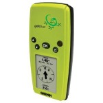
The GPS of choice for me is the Garmin Geko 201. I like it because it is very light, very small and very easy to use. Its great value for money too. It is basic, but i also think that is a plus point. It tells you where you are, it keeps track of where » read more »
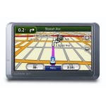
So we’ve recently upgraded our Satellite Navigation System. We wanted to stick with Garmin cos we liked the Street Pilot so much. We plumped for the nüvi 205WT based on a great review in “Which?” (Feb 2009) were it scored a rating of “Best Buy – Exceptional Value”. Her voice is relaxed and less critical » read more »
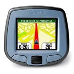
Whilst not related to walking at all; it is still a GPS unit – so i thought i’d mention out Satellite Navigation System (Sat. Nav.). We have the Garmin Street Pilot i3. Its a simple bottom of the range model and so good value for money. It has a patient female voice and we tend to affectionately » read more »
Author: Phil Newby