Corsica GR20 2004
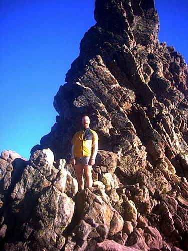

scariest rope bridge
- DAY1: To Calenza, via Paris
- DAY2: to Refuge d’ Ortu du u Piobbu
- DAY3: to Refuge de Carozzu
- DAY4: to Haut Asco scariest part of the entire holiday on a wobbly rope bridge!
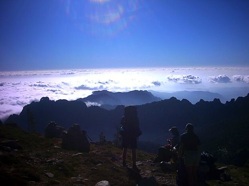
- DAY5: to Bergeries de Ballone via the Cirque de Solitude and some interesting via ferratta
- DAY6: to Hotel Castel di Vergio
- DAY7: to Refuge de Manganu
- DAY8: trapped at Refuge de Manganu by appalling weather.
- DAY9: A very early start to double up a couple of tough stages over some fantastic high scrambling. We took the alternative High Route to L’Onda

Cirque de Solitude
- DAY10: to Vizzavona
- DAY11: Another doubling up of two easier stages. Lunch at Capanelle & finnished at Col de Verdi
- DAY12: to Refuge d’Usciolu An unexpectedly tough day, we were obviously getting tired.
- DAY13: to Refuge d’Asinau
- DAY14: high level ‘Alpine Variant’ to the eccentric Refuge Paliri
- DAY15: Walked out to Conca and got the last bus back to Calenza
We went towards the end of the season, this has the advantages that the weather is cooler, the route, refuges & campsite’s are less crowded, but there is some disadvantage in terms of reduced availability of some services including public transport.
We used two main guide books; Paddy Dillon’s GR20 Cicerone Guide & GR20 – A travers la montagne corse (Topo 067) which has all the maps (1:25000) you will need. Paddy’s book is now a little out of date and food can be obtained from most refuges and you don’t really have to carry anything like as much food as he suggests. We also beleive in keeping well fed, and found that short food breaks every hour worked well for us.
What we took
We believe that enjoyment is inversly proportional to your pack weight – that is travel as light as you can. We got our packs down to 9kg before food & water. You will need to carry 3kg (litres) of water and one or two day’s breakfasts & lunches + some other emergency food on top of this. We bought food and meals in Refuges/Hotels where ever we could to keep the weight down. This is was our kit list…
- Rucksack (60 litres is sufficient)
- Terranova Laser 2 person Tent (1.2kg)(shared)
- 6 steel tent pegs (very important as the ground can be rock hard)
- Cheap pierce-able Gas/Gaz Cooker (shared)
- Small aluminum pan (shared)
- Two lightweight dehydrated meals
- Lightweight Boots (Hi-tec v-light)
- Small down sleeping bag (rated to +5°C)
- Lightweight 3/4 Therma-rest (worth the additional weight over a carry-mat)
- Leki Trekking Pole
- Spoon-fork & Knife
- Cup (never used)
- Water bottles (platypus 2 + 1 litres)
- Minimal Wash Kit; shampoo (50ml), “wet wipes”, toothbrush & paste (15ml), small towel, travel wash (50ml), toilet roll.
- Minimal First Aid Kit; painkillers, compeed, imodium, puritabs, piriton
- Small Repair Kit; cable ties, gaffa tape & needle + thread
- Sun cream (100ml) & lip block
- Ear Plugs
- Small Head Torch
- Compass, Map, Whistle
- Small Digital Camera (+ spare batteries)
- Passport, Insurance, E111,
- Cash (c.a. 700 Euro each) & Visa-Card
- Lightweight Waterproof Jacket (gore-tex pac-light)
- Lightweight Waterproof Trousers (gore-tex pac-light)
- Small pair of Gloves (never used)
- Sun Hat
- Warm balaclava
- Pertex Shirt – 1
- Long sleeved thermal top – 1
- Thin Fleece – 1
- Light zip off trousers – 1 pair
- Shorts – 1 pair
- Socks – 3 pairs
- Pants – 2 pairs
What we’d do differently
If i did it again i would take an extra coolmax tee-shirt and i would not have taken the gas stove as there was plenty of free cooking facilities available at the refuges.
More on the GR20:
The GR 20 is Corsica’s most famous footpath. It is 173km long and traverses the island from the north west to the south east and involves 9900m of ascent. If your group is physically fit, it will take you between 15 and 20 days (with 4 to 8 hours walking time each day).
The GR20 is very physically demanding, and this can be exacerbated by the heat of the island’s weather. I would recommend group members do not consider participating in this trip unless they are in a good state of physical fitness, with plenty of stamina and feeling able to endure long ascents in hot weather. If walking north to south, there is a lot of ascent on the first few days (approx 1000m) and at least as much descent. Some clients might find the ground underfoot hardgoing.
The paths along the GR20 are well marked with blobs of paint. There are some variants, and a few sections can be combined to make up longer days. Your choice of whether to do these will largely be dependent on your group and the weather conditions.
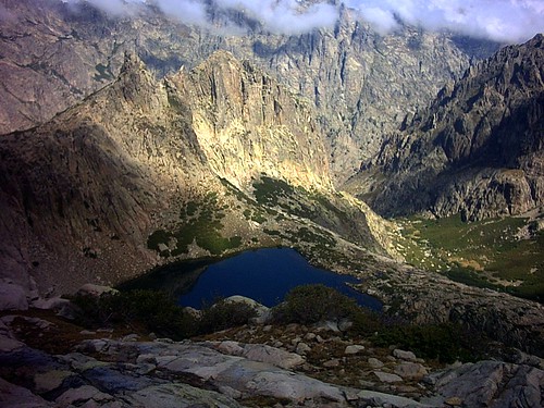
The GR20 does involve crossing very rocky terrain which on the whole is very grippy but can be quite “interesting” when wet! On a few sections there are a number of slabs which slope off at rather tricky angles. Your group members will need to be confident moving on rock and with scrambling. Some parts of the route are quite exposed, so a good head for heights is recommended. There are a number of sections, most notably “le cirque de la solitude”, where fixed chains and some ladders are bolted into the rock. These could be protected with slings or a rope if members of your group are nervous, but be aware that the path into and out of the cirque can be very busy, so the ability to move efficiently and effectively is quite important.
While you need to ensure your pack is light, you will need to ensure you carry plenty of water, perhaps 3 – 4 litres. There is virtually nowhere en route during each day to top up.
When to do it: snow can be present in the mountain passes between November and April. As the huts are open between June and September, this is the best time to complete the route. Mid July to mid August can be extremely hot and busy, so perhaps late June and early September are the best time to complete the trek.
Accommodation on the GR20:
This is mainly in mountain refuges. These are mostly built and maintained by the Parc Naturel Régional de la Corse (PNRC). They are open and manned by a guardian from mid June to end September. The refuges are very basic, providing bed space (take a sheet sleeping-bag), drinking water (eau potable), gas cooker and toilet (bring your own toilet paper!), and occasionally an open air shower. The huts have a capacity of 25 to 35 places, and during summer tend to be a bit overcrowded.
When I did the GR20 (2004), it was not possible to book refuge spaces in advance. In mid summer the route can be very busy, so if you are thinking of taking a reasonable sized group, it could be worth waiting until the start of September. Wild camping is not permitted on the route, but you are allowed to camp in the space allocated outside of each of the refuges. The charge for this is very small and there is the added bonus of being able to buy dinner. If you are camping, take good steel tent pegs and a decent thermarest as the ground can be very hard!
Despite what many of the guide books say, it is possible to buy food at most of the refuges, even of you are not staying at them (the Refuge di Paliri did not sell food in 2004). You can usually buy an evening meal and snacks for lunches / breakfast. If you are doing the GR20, there are a couple of days when you drop down to areas with hotels. These are strategically well placed for taking showers!
Maps:
GR20 – Across the Mountains of Corsica Federation Francaise de la Randonnee Scale: 1:25,000 / 50,000. This publication has all the maps in that you will need and can be bought for £14.95 from Stanfords. Paddy Dillon’s book is also extremely useful.
What to do in an emergency:
PGHM are the mountain rescue gendarmes in Corsica. They can be called on: 04 95 61 13 95. Other emergency numbers include: 18 (fire brigade), 17 (gendarmes), 15 (emergency doctor service), and 112 (the euro mobile help number).
Weather:
Corsica has a Mediterranean climate – at least at coastal levels. Prevailing winds are south-westerly, westerly and north-westerly. This varies considerably with altitude. At about 1500 metres the climate becomes alpine. (Don’t forget the island goes from sea level to 9000 feet, with a land mass of only about 100 by 50 miles). Micro climates give a wide variety of temperatures and precipitation. This is especially true between north-west and south-east, as the main mountain range divides the island roughly in half. In mountain areas, there are frequent late afternoon thunder storms, and the number of lightening strikes per km is very high.
There is a high risk of forest fires during the summer. Very dry weather can lead to a shortage of water supplies in August, and if you are out walking, you will find very little water en route.
Summers are long – from May till October. Winters can be cold and generally there’s snow on the highest peaks until June, but by then, the ambient temperature is in the mid-20s. From July – September the average is 27°. The best months for walking are June and September.
For a weather forecast, visit Meteo France www.meteo.fr/meteonet/temps/region17/prev/regprev.htm to see a regional forecast for Corsica – for today and the following four days. Otherwise, you can telephone 08 92 68 02 20 for a forecast
What are we likely to see?
In terms of fauna, a lot of lizards, a number of different snakes, and mouflon. For flora, you will be able to smell the laricio pines, and the ‘maquis’ very spiny plants which cover the ground and are highly aromatic.
What are we likely to eat?
We found some very interesting cheeses – a few that made your eyes water, others that were very pleasant. Wine is very reasonably priced, whereas beer is very expensive. Brocciu (a whey-based goat or sheep cheese produced from the autumn to the middle of summer) is the basis for many sweet and savoury dishes: doughnuts and pies, pasta fillings and sauces.
How do we get there?
By plane or ferry (beware of strikes!).
Coming by sea from France – there are ferries (Corsica Ferries, SNCM & CMN) from Nice, Marseille & Toulon to Ajaccio, Bastia, Ile Rousse & Calvi and other ports.
Coming by air – there are airports in Ajaccio (SW), Bastia (NE), Calvi (NW) & Figari (S) that have regular daily services from Marseille and Nice (CCM Airlines) and in the case of Ajaccio & Bastia, daily from Paris. There are Paris services to Calvi & Figari several times a week; and services (more frequent in summer) from other French regional airports. You can fly from Manchester to Paris, Paris to Marseille and Marseille to Calvi. There are now direct flights to Bastia.
How do we get around once we’re on the island?
Travel once you’re on the island can be tricky if you’re relying on public transport: it’s worth researching bus and train times in advance. Again, buses can be quite affected by strikes. A really useful website is: http://www.corsicabus.org/
Driving regulations:
The law insists that you always carry your driving licence and car hire documents. Random checks and breath testing are quite common. Although recently, a lot of work has been done to Corsican roads, most of them, particularly country and mountain roads, are narrow and winding and some are in poor state of repair. Smaller vehicles are easier to navigate through the narrow roads and some of these tracks may sometimes have bumps and pot-holes, especially after periods of rain.
Getting connected:
The electricity system on Corsica uses the European style 230 volts 50 hertz AC current. The sockets are round hollows in the wall with two holes and a protruding pin (for protective earth), no notches, no contact springs, as they are in France
Electric Plug Details: European plug with two circular metal pins
British electrical appliances (240 volts) can be used without problems. If you want to use devices designed for 110 volts, make sure they can tolerate 50 hertz (most shavers can’t, radios can) and get yourself a transformer.
There is no available electricity in mountain refuges. They do have electricity (solar panels and accumulators), but the current is 24 volts DC and is not accessible.
Mobile phones:
Generally, mobile phone coverage in Corsica is very good – except for the more remote and/or mountainous areas i.e. most of the GR20! If you are using a British mobile phone in Corsica your call must be prefixed by 00 33 and you should then drop the first 0 of the Corsican phone number.
Corsica in brief:

Map of Corsica
Corsica is in the Tyrrhenian Sea in the western Mediterranean, just above Sardinia.
Its highest point is Monte Cintu at 2710 metres. It has twenty other mountains above two thousand metres and the average altitude is 560m. Corsica has the highest mountains and the most rivers of any Mediterranean island. The mountains run roughly north west to south east and cut the island in two.

Its flag:
The Testa di Moru, the black Moor’s head on a white background is the national flag of Corsica. The Moor’s head with a white bandeau was adopted in 1762 as the official emblem of independent Corsica. It was inherited from the kings of Aragon, who were invested with Corsica by the Pope in the Middle Ages.
Its politics:
While Corsica is independent, administratively, it forms two Départements and one Region of France. Haute Corse (2B) is to the north and its capital is Bastia. To the south is Corse du Sud (2A) with its capital in Ajaccio, which is also the regional capital and is the seat of the regional government – the Collectivité Territoriale de Corse (CTC).
Its language:
French is the official language and spoken by everyone. Corsican (Corsu) is also spoken, although it is not currently legally recognised. In the mountain areas, very few people speak English. Corsican people really appreciate English people making an effort to speak to them in French.
Its currency:
Corsica is in the EU and the currency is the Euro. If you are embarking on a walking expedition, and will be spending little time in any of the towns, it is strongly recommended that you carry enough cash with you to cover your costs. There are only a few hotels in the mountain areas that accept credit cards, and there is nowhere to draw out additional cash.
Compared to the UK (except perhaps for London), it can be quite expensive to buy a meal in the towns. Food and accommodation in the mountain areas is however very reasonably priced and of ample quantity.
Walking in Corsica
There are a wide range of walking opportunities available in Corsica, the most famous of which is the GR20, which I shall describe in more detail later.
A few of the suggested walks include:
“Sentiers de Pays” – local paths. Local paths have been developed in eight micro regions of the island’s interior. Designed for more novice clients and with a family focus, these paths explore the island’s cultural and natural heritage in sections which are marked out for 2 to 5 hours of walking.
Mare a Mare Sud – coast to coast south. This path crosses from coast to coast across the interior of southern Corsica – Porto Vecchio to Propriano. The route is made up of five, 4 – 5 hour sections. It is possible to do all year round.
Mare e Monti Sud – sea and mountains of the south. This path follows a balcony route above the sea and is accessible to all. It explores the traditional interior of Corsica and the shores of the Ajaccio gulfs and Valincu. The route takes 5 days, with a daily average of 5 hours walking. It is possible to do all year round.
Mare e Monti – sea and mountains. The Mare e Monti route stretches between sea and mountains, from Calenzana to Cargèse. It is quite a strenuous walk but without technical difficulty. It usually takes 10 days, but can be done in 7. Each daily stage takes between 4 and 6 hours. Accommodation is in gites d’etapes in the villages. It is possible to do all year round but the best time is in the spring and autumn.
Mare a Mare Centre – coast to coast central. From Ghisonaccia to Ajaccio, this route involves seven 4 to 6 hour stages. Because this path crosses 1500 metre passes, it is only feasible between April and November. It crosses very varied landscapes and passes through authentic villages.
Mare a Mare Nord – coast to coast north. From Moriani to Cargèse this walk involves 12 stages of 4 to 6 hours walking. Because this path crosses 1500 metre passes, it is only feasible between April and November. The path stretches across the feet of the highest summits – Monte Cintu, Paglia Orba…
For more information on the range of walks throughout Corsica, visit www.parc-naturel-corse.com
The Parc Naturel Régional de Corse produces a leaflet for walkers looking for accommodation in gîtes d’etape and refuges. This can be requested by e-mail through visiting the above website.
Author: Phil Newby
Trying to download Gr20 gpx file.Is it available, if so where is it found.
Thanks
Sorry we don’t have that one available, but if you do find or record one we would be very happy to host it on our website
Cheers
phil
What an informative website! Thanks. I am not in a position nowadays to tackle the G20, but have done most of the Sentier du Douanier over the top of Cap Corse. I’m doing the last stretch to Centuri in June. A stroll compared to G20, no doubt, but enough for me.
Thanks for taking the trouble to post this guide. Very useful for my forthcoming trip.