Hill Bagging Tick Lists for Members
Members can use the lists of hills and waypoints as your own personal hill bagging tick-lists.
First register as a Member, then Log-in and go to the Hill list of choice.
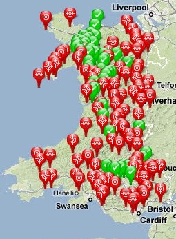
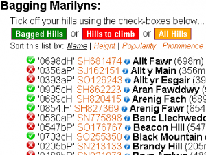
Just tick the check-box next to the names of the hills you’ve climbed, we will record and display each hill’s “bagged” status on all your hill lists and the maps too (green for climbed and red for not yet climbed).
This allows you to “tick-off” your Wainwrights, Munros, Hewitts, Nuttalls, Marilyns and so on as you do them. This is really useful for planning bagging expeditions and the map view helps form your optimum bagging strategy.
Best of all, as it is driven by a database, it automatically cross-references the hills you have climbed against all the lists of hill types, and also across different areas… So if you tick off “Sca Fell Pike” in the Wainwrights list, it will also be ticked off in the Hewitts, Nuttalls and Marilyns lists, and also in the “Area 34: Lake District” hills list as well.
- Register as a Member
- then Log-in
- finally go to the Waypoints & Hills Index and navigate to the hill list of your choice…
For Example: here’s my own “Welsh Marilyns“ Bagging page
New Features…
- ‘Bagging’ is now available for all Trigpoints…
- For the more competitive among you there is also a league table available at… http://www.haroldstreet.org.uk/members/bagging-league.php
- Import your climbed hills from GPSU, CSV or GPX files of waypoints… http://www.haroldstreet.org.uk/waypoints/importer.php
- If you share your GPX routes in the members section they will automatically be checked for hills & trigpoints and added to your hill-bagging account.
- There is also the possibility of adding your comments & photos to any of the hills or trig-points on this website
- Hill bagging is now available for all the Irish hills listed too.


Wainwright list please
Its here;
http://www.haroldstreet.org.uk/wainwrights/
but you’ll need to log in first to use it…
I used to be able to find not just the trig point,gid ref but also other bits of information ,like when it was built etc is that still available, I used to just put in the bench (OSBM number )and all the relevent info would pop up.Am I looking in the wrong place or can you recommend another site that gives this feature.
many thanks
colin
Hi Colin
I think you are looking for http://www.trigpointinguk.com/trigtools/
Phil Newby
Mountain GPS Waypoints & Walking Routes
http://www.haroldstreet.org.uk
Hi, this website looks like a great resource, however I am struggling trying to use it on intuition. I have tried to log that I’ve bagged the trig point Blackstone Edge, and click the box to say “climbed”, however it does not appear to have saved that I’ve bagged that trig point when I go back onto the map, and I can’t seem to find a summary page of what you have bagged. What am I doing wrong?
Sorry to hear you are having difficulties with the site.
I assume your login must have worked OK or you wouldn’t even see the little check box.
Here is a quick link to Blackstone Edge… http://www.haroldstreet.org.uk/waypoints/download/?hill=Blackstone+Edge&hillnumber=5319
Can you check that the title bar is Orange (not red) and has “Logged in:- ‘GeoJools'” in green next to “Bagging Blackstone Edge”?
Then you ought to be able to tick it off using the tick box next to its name i.e. directly under “Tick off Blackstone Edge using the check-box below…”.
Once ticked the Waypoint Name ‘0474ap’ should change from pink to green, and the icon on the map should also change to a green tick. (Then when you refresh the page your user name should also appear in the blue list near the bottom.)
All your bagged hills & trigpoints should also be listed on this page…
http://www.haroldstreet.org.uk/members/contributions.php?user=me
The website does require “Javascript” to be able to change the colours & icons so if your web browser is not enabled for Javascript then it won’t work.
I guess one thing that might be confusing is that Blackstone Edge – the Hill & Blackstone Edge – the Trigpoint are considered to be one single bagging target by this site (and so share a single page) and your tick counts for both, despite them being 166m apart (this is nearing the maximum for the site so it is an unusual example more often trigpoints and summits are much closer together if not exactly the same).
Is that any help?
Dear Phil,
Thanks very much for this website, a great source of information. I can’t work out how to download members’ gpx files for use on my own device. Am I just blind and don’t see the button/link, or is this not possible? Thanks.
Roger
Hi Roger
1st Click on the title of the route in the routes list or the waypoints of choice in the waypoint lists
for example “Yorkshire Three Peaks Route” will take you here…
http://www.haroldstreet.org.uk/yorkshire-3-peaks-route/
then the big green “GPX file” download button on the left should start the GPX file downloading
GPX File
Hello the Needles, Isle of White , I have seen the lighthouse = tick for lighthouse baggers but nit stood on the summit which is required for hill baggers, its a subtump,so how can I tick for the lighthouse but not tick for the subsume?
Hi Sorry, the two items are too close together for this site to make a distinction. Its up to you to decide if you are bagging it as a hill or a light house.
Please can you tell me if it’s possible to import all my bagged hills from Hillbagging.co.uk?
Hi Jez – yes see this page for details https://www.haroldstreet.org.uk/other/importing-your-hills-from-www-hill-bagging-co-uk/
Hi! New member here, will be adding my routes and trig point bags over time – just read the response to Jez’s question. I logged them all on my my site if anyone wanted any information about trig points in Herefordshire – https://trig-bagging-herefordshire.co.uk/. Thanks!